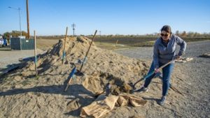
From Sacramento News & Review – Sitting at the intersection of the Yuba and Feather Rivers, Yuba County has been described by the US Army Corps of Engineers as being “most prone to severe flooding of any river valley in the United States.” For this reason, it’s important that significant effort be made to reduce the risk of flooding as much as possible, and that Yuba County residents be informed of their personal flood risk. Fortunately, residents have several tools at their disposal to help them do that. Leading the charge is Yuba Water Agency. Formed in 1959 in response to a 1955 flood in next-door Sutter County that displaced 40,000 residents and killed 38, Yuba Water Agency has worked tirelessly over the decades to construct the New Bullards Bar Reservoir, to invest in strengthening the county’s levee infrastructure and to utilize technology to help reduce flood risk. (more)
From gt Industry Insider– With the goal of further reducing the risk of catastrophic flooding, a project kickoff meeting was held last month to better understand how the Center for Information Technology Research in the Interest of Society and the Banatao Institute (CITRIS) could use research and technologies to enhance levee monitoring and management in Yuba County. CITRIS leverages the research strengths of different University of California campuses. The April 19 meeting also involved site tours of local levees, and it provided a chance for the researchers from CITRIS to meet levee managers. (more)
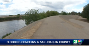
From KCRA3 – According to the San Joaquin Area Flood Control Agency, the area’s current levees do not meet state requirements for 200-year flood protection and soon may not meet the federal requirements. “In that case, properties would be mapped into a special flood hazard area, and any property owner with a federally backed mortgage would be required to purchase flood insurance,” said Kim Floyd, public outreach manager for San Joaquin Area Flood Control Agency. Premiums in those special flood hazard areas average about $1,700 yearly, but if the project is approved, those same property owners would have to pay, on average, about $85. The board of directors authorized balloting for a proposed property assessment for more than 22,000 properties in the area. (more)
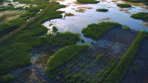
From The Sacramento BEE– A thousand years ago, native fish and birds rested in a fertile floodplain at the intersection of the Sacramento and Feather rivers and Butte creek along their migratory routes. Since the turn of the 20th century, the area has been engulfed in rice fields. But in the next decade, the bygone natural floodplain is coming back. That’s after California conservation nonprofit River Partners secured millions for restoration work on 750 acres from state wildlife agencies and Apple Inc., the multinational tech company. (more)

Click to access each report below:
FEMA Update 2024
NOAA Update 2024
From DWR – California’s changing climate brings new challenges each year for water managers as they navigate extreme shifts from drought to flood while working to ensure safe, reliable water supplies for California’s 39 million residents. Water managers address these challenges in their local watersheds, which are often at the forefront of the impacts of climate change. The Department of Water Resources (DWR) is working with local and regional water agencies such as the Merced Irrigation District to conduct cutting-edge climate vulnerability assessments of watersheds in the San Joaquin Valley and evaluating how flood protection and groundwater recharge strategies can be used to adapt to climate vulnerabilities. (more)
From The Mercury News – Atmospheric river storms are like punches in a boxing match. A flurry of weak ones are OK. But it’s best to avoid the big knockout blows.
That’s exactly what happened in California this winter. Scientists say that from Oct. 1 to April 1, the state actually received more atmospheric rivers, the famous moisture-laden meteorological events that are critical to the water supply, than it did last year — 44 this winter compared to 31 last winter. But the intensity made all the difference. Statewide, California had just 2 strong atmospheric rivers this winter, compared with 7 last year. Many of the biggest this winter hit Washington and Oregon instead. The result was, for the most part, a remarkably, blissfully average rainy season for California. (more)

Video from NOAA Fisheries and mavensnotebook.com – To the residents of California’s Central Valley, salmon represent family, culture, jobs, community, and identity. The Central Valley has a rich salmon culture. Join us as we talk with community members and learn how they connect with Central Valley salmon. Salmon have been here for millions of years. They have been central to the culture and economy of Indigenous people since time immemorial. They still are to this day. In the mid-to-late 1800s, European settlers exploited West Coast salmon in excess, and overharvest continued into the 1970s. As native salmon runs declined, hatchery programs replaced the native runs. Meanwhile, impacts from industry, agriculture, mining, forestry, and urban development filled floodplains, dredged and channelized rivers, contaminated water, removed streamside forests, and built dams, blocking the habitat salmon need to spawn and rear. Together with partners and community members, we are working to ensure salmon are a vibrant contributor to a thriving Central Valley. Where they are valued as a part of our culture, their important role in our ecosystem, for the way they support jobs, recreation, and feed our families. (more)
As part of the Central Valley Flood Protection Plan implementation efforts, the Flood Board has released the Sacramento San Joaquin Drainage District Assessment District Feasibility Study – Public Draft Report of Findings. We respectfully request public review and comment on the Public Draft Report of Findings. The 2-week public review period will close on May 3, 2024.
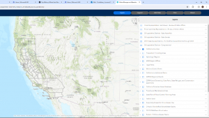
From California Department of Water Resources (DWR) – DWR’s Water Management Planning Tool has been relaunched as the Water Management Boundary Tool. It is an interactive map that allows users to overlay geographic information system (GIS) layers onto a California map and illustrate entities involved in water management in a given area. The tool can assist local agencies with their responsibilities related to the California Water Plan, integrated regional water management, and the Sustainable Groundwater Management Act. (more)